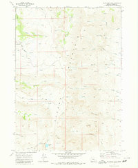
1968 Map of Wildhorse Lake
USGS Topo · Published 1980About this map
Steens Mountain dominates this high-altitude survey, showcasing the sharp topographic relief and hydrological network of eastern Oregon. The alpine environment is centered around Wildhorse Lake and its surrounding drainage, where Little Wildhorse Cr flows through the steep Canyon. Human presence is sparse and primarily tied to recreation and seasonal use, evidenced by the Jackman Park Campground and remote outposts like Grant Place and The Hunters Cabin. The map documents a landscape defined by water sources, with scores of Springs feeding into drainage systems like the Little Blitzen River and Big Indian Creek. A distinct Radio Facility near the mountain peak and the presence of a Jeep Trail and Loop road provide insight into the infrastructure required to navigate this steep, glaciated terrain in the late 1960s.
Find a feature on this map
36 named features on this map. Tap any name to fly to it.
Don’t see what you’re looking for? This feature index may not catch every label — zoom into the map to look around manually.
Map Details
Editions of this 1968 Wildhorse Lake Map
3 editions found
Other maps of this area

1955 · Adel
USGS Topo · 1:250,000

1957 · Adel
USGS Topo · 1:250,000

1958 · Adel
USGS Topo · 1:250,000

1962 · Adel
USGS Topo · 1:250,000

1968 · Fish Lake
USGS Topo · 1:24,000

1968 · Wildhorse Lake
USGS Topo · 1:24,000

1968 · Big Pasture Creek
USGS Topo · 1:24,000

1968 · Alvord Hot Springs
USGS Topo · 1:24,000

1968 · Ankle Creek
USGS Topo · 1:24,000
1968 · Mc Coy Ridge
USGS Topo · 1:24,000