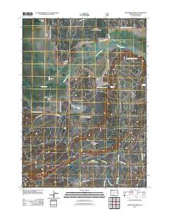
2011 Map of Wildhorse Ridge
USGS Topo · Published 2011About this map
The Williamson River and its intricate drainage network, including the Williamson River Ditch and Jack Creek, define this Klamath County landscape. In this early 21st-century survey, agricultural and ranching operations are prominent, notably at Kittredge Ranch, Summers Ranch, and the Johnson Barn. The terrain transitions from the marshy lowlands surrounding Hog Island and Abraham Flat to the more elevated prominences of Wildhorse Ridge and Sagebrush Point. A complex system of forest roads, such as Nat For Dev Rd 7631 and Meadow Creek Rd, provides access across the basin. The map documents a rural environment where water management and topography dictate land use, from the grassy expanses of South Flat to the riparian corridors of Clover Creek and Meadow Creek.
Find a feature on this map
25 named features on this map. Tap any name to fly to it.
Don’t see what you’re looking for? This feature index may not catch every label — zoom into the map to look around manually.
Map Details
Editions of this 2011 Wildhorse Ridge Map
This is the sole edition of this map. No revisions or reprints were ever made.
Other maps of this area

1889 · Klamath
USGS Topo · 1:250,000

1894 · Klamath
USGS Topo · 1:250,000

1935 · Chemult
USGS Topo · 1:96,000

1941 · Chemult
USGS Topo · 1:125,000

1955 · Crescent
USGS Topo · 1:250,000

1955 · Klamath Falls
USGS Topo · 1:250,000

1957 · Crescent
USGS Topo · 1:250,000

1957 · Klamath Marsh
USGS Topo · 1:62,500

1958 · Crescent
USGS Topo · 1:250,000

1958 · Klamath Falls
USGS Topo · 1:250,000