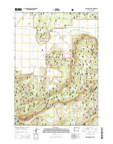
2014 Map of Wildhorse Ridge
USGS Topo · Published 2014About this map
Winema National Forest encompasses the vast majority of this landscape, where the high desert meets complex water management systems. The western portion of the map is defined by industrial-era water engineering, including the Williamson River Ditch, Y J Canal, and Kittredge Canal. These features suggest a history of agricultural reclamation and water diversion in a region characterized by significant landforms like Hog Island and the expansive Abraham Flat.
Find a feature on this map
31 named features on this map. Tap any name to fly to it.
Don’t see what you’re looking for? This feature index may not catch every label — zoom into the map to look around manually.
Map Details
Editions of this 2014 Wildhorse Ridge Map
This is the sole edition of this map. No revisions or reprints were ever made.
Other maps of this area

1889 · Klamath
USGS Topo · 1:250,000

1894 · Klamath
USGS Topo · 1:250,000

1935 · Chemult
USGS Topo · 1:96,000

1941 · Chemult
USGS Topo · 1:125,000

1955 · Crescent
USGS Topo · 1:250,000

1955 · Klamath Falls
USGS Topo · 1:250,000

1957 · Crescent
USGS Topo · 1:250,000

1957 · Klamath Marsh
USGS Topo · 1:62,500

1958 · Crescent
USGS Topo · 1:250,000

1958 · Klamath Falls
USGS Topo · 1:250,000