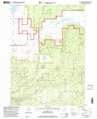
1998 Map of Wildhorse Ridge
USGS Topo · Published 2000About this map
The Williamson River winds through this landscape on the eastern edge of the Klamath Marsh National Wildlife Refuge, marking a transition from marshy bottomlands to the forested heights of the Winema National Forest. The map documents a managed water landscape where the Kittredge Canal Levee and Y J Canal Levee steer the drainage around Hog Island and Summers Ranch.
Find a feature on this map
24 named features on this map. Tap any name to fly to it.
Don’t see what you’re looking for? This feature index may not catch every label — zoom into the map to look around manually.
Map Details
Editions of this 1998 Wildhorse Ridge Map
This is the sole edition of this map. No revisions or reprints were ever made.
Other maps of this area

1889 · Klamath
USGS Topo · 1:250,000

1894 · Klamath
USGS Topo · 1:250,000

1935 · Chemult
USGS Topo · 1:96,000

1941 · Chemult
USGS Topo · 1:125,000

1955 · Crescent
USGS Topo · 1:250,000

1955 · Klamath Falls
USGS Topo · 1:250,000

1957 · Crescent
USGS Topo · 1:250,000

1957 · Klamath Marsh
USGS Topo · 1:62,500

1958 · Crescent
USGS Topo · 1:250,000

1958 · Klamath Falls
USGS Topo · 1:250,000