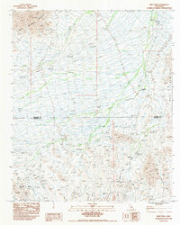
1983 Map of Wiley Well
USGS Topo · Published 1983About this map
The Bradshaw Trail traverses this arid region of the Colorado Desert, following a path long established for overland travel between the Colorado River and coastal California. The landscape is defined by the convergence of several major mountain systems, including the Chuckwalla Mountains to the northwest, the Mule Mountains to the east, and the Palo Verde Mts in the southeast. This 1983 survey documents a remote area managed for both recreation and resource extraction, evidenced by the Wiley Well Campground and the Geode Beds, a site known to rockhounds and mineral collectors. Numerous drainage patterns like the Sand Wash dominate the alluvial fans between the peaks, while small-scale mining activity is noted through scattered Prospects and a specific Mine Shaft located near the boundary between Riverside Co and Imperial Co.
Find a feature on this map
15 named features on this map. Tap any name to fly to it.
Don’t see what you’re looking for? This feature index may not catch every label — zoom into the map to look around manually.
Map Details
Editions of this 1983 Wiley Well Map
This is the sole edition of this map. No revisions or reprints were ever made.
Other maps of this area

1942 · Blythe
USGS Topo · 1:250,000

1952 · Mc Coy Spring
USGS Topo · 1:62,500

1952 · Sidewinder Well
USGS Topo · 1:62,500

1953 · Palo Verde Mountains
USGS Topo · 1:62,500

1953 · Chuckwalla Spring
USGS Topo · 1:62,500

1954 · Salton Sea
USGS Topo · 1:250,000

1955 · Salton Sea
USGS Topo · 1:250,000

1959 · Salton Sea
USGS Topo · 1:250,000

1963 · Salton Sea
USGS Topo · 1:250,000

1965 · Salton Sea
USGS Topo · 1:250,000