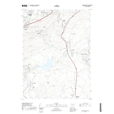
2019 Map of Wilkes-Barre East
USGS Topo · Published 2019About this map
Wilkes-Barre anchors the northwestern corner of this study, where the urban grid gives way to the steep elevations of Wilkes-Barre Mtn and Wyoming Mtn. This 2019 survey documents the complex interface between the developed valley and the forested uplands of Luzerne County. Significant local history is preserved in several ecclesiastical sites, including the Holy Trinity Lithuanian Cem and the Saint Marys Church of the Maternity Cem Old near Georgetown. To the south, the landscape is defined by natural water features like Crystal Lake and Mud Run Swamp, along with specialized aviation infrastructure at Rosenzweig Airport. The southeastern reach shows the distinct character of Bear Creek Village and Penn Lake Park, where local industry is still hinted at by labels like Ochre Mill and Oliver Mills. The map captures a topography shaped by deep drainages such as Deep Hollow and the notable Whirlpool Canyon Falls.
Find a feature on this map
104 named features on this map. Tap any name to fly to it.
Don’t see what you’re looking for? This feature index may not catch every label — zoom into the map to look around manually.
Map Details
Editions of this 2019 Wilkes-Barre East Map
This is the sole edition of this map. No revisions or reprints were ever made.
Other maps of this area

1889 · Scranton
USGS Topo · 1:62,500

1891 · Wilkesbarre
USGS Topo · 1:62,500

1891 · Scranton
USGS Topo · 1:62,500

1893 · Pittston
USGS Topo · 1:62,500

1893 · Scranton
USGS Topo · 1:62,500

1894 · Wilkesbarre
USGS Topo · 1:62,500

1922 · Stoddartsville
USGS Topo · 1:62,500

1924 · Stoddartsville
USGS Topo · 1:62,500

1943 · Scranton
USGS Topo · 1:125,000

1943 · Stoddartsville
USGS Topo · 1:62,500