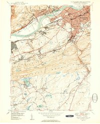
1950 Map of Wilkes-Barre West
USGS Topo · Published 1950About this map
The Susquehanna River carves a path through this coal-rich landscape, where the anthracite industry is visible in the numerous strip mines and mine dumps lining the valley. In the post-war years, the urban core of Wilkes-Barre is densely developed, featuring prominent institutions like Meyers High Sch and Dodson Sch. To the south, the landscape rises toward Wilkes-Barre Mountain and Penobscot Mountain, while smaller settlements such as Warrior Run and Sugar Notch cluster along the Central RR of PA. This era reveals a complex rail network, including the Delaware Lackawanna and Western RR, which supported the region's industrial output. Away from the valley floor, the character of the land shifts toward leisure and local landmarks, including the lakeside community at Nuangola Lake and the peak of Haystack Mtn.
Find a feature on this map
91 named features on this map. Tap any name to fly to it.
Don’t see what you’re looking for? This feature index may not catch every label — zoom into the map to look around manually.
Map Details
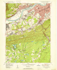
Editions of this 1950 Wilkes-Barre West Map
2 editions found
Other maps of this area

1891 · Wilkesbarre
USGS Topo · 1:62,500

1891 · Harveys Lake
USGS Topo · 1:62,500

1893 · Harvey Lake
USGS Topo · 1:62,500

1893 · Pittston
USGS Topo · 1:62,500

1894 · Shickshinny
USGS Topo · 1:62,500

1894 · Wilkesbarre
USGS Topo · 1:62,500

1943 · Scranton
USGS Topo · 1:125,000

1946 · Sybertsville
USGS Topo · 1:31,680

1946 · Nanticoke
USGS Topo · 1:31,680

1946 · Kingston
USGS Topo · 1:24,000