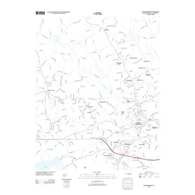
2013 Map of Wilkesboro
USGS Topo · Published 2013About this map
North Wilkesboro and Wilkesboro anchor this 2013 survey of the upper Yadkin Valley, showing the modern suburban and industrial development along the Yadkin River. The map illustrates the convergence of several major water systems, including the Reddies River, Moravian Cr, and Cub Cr, which historically shaped the region's commerce and settlement patterns. The western edge is defined by the massive W Kerr Scott Reservoir, a critical hydrological feature for the county.
Find a feature on this map
306 named features on this map. Tap any name to fly to it.
Don’t see what you’re looking for? This feature index may not catch every label — zoom into the map to look around manually.
Map Details
Editions of this 2013 Wilkesboro Map
This is the sole edition of this map. No revisions or reprints were ever made.
Other maps of this area

1889 · Wilkesboro
USGS Topo · 1:125,000

1891 · Wilkesboro
USGS Topo · 1:125,000

1953 · Winston-Salem
USGS Topo · 1:250,000

1955 · Winston-Salem
USGS Topo · 1:250,000

1962 · Winston-Salem
USGS Topo · 1:250,000
1966 · Gilreath
USGS Topo · 1:24,000

1966 · Roaring River
USGS Topo · 1:24,000
1966 · Boomer
USGS Topo · 1:24,000
1966 · Moravian Falls
USGS Topo · 1:24,000

1966 · Wilkesboro
USGS Topo · 1:24,000