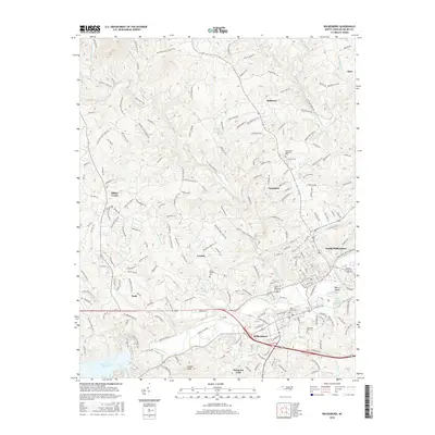
2016 Map of Wilkesboro
USGS Topo · Published 2016About this map
The Yadkin River and Reddies River converge at the heart of this North Carolina survey, framing the commercial and residential centers of Wilkesboro and North Wilkesboro. To the west, the expansive W Kerr Scott Reservoir transitions into a landscape of foothills and winding creek valleys. Local history is preserved in several burial grounds, including Union Tarheel Cem and Saint Pauls Cem, while the Wilkes Co Airport and the Tyson facility mark the modern industrial footprint of the region. The map reveals a dense network of family-named roads like John McGrady Rd and Elledge Mill Rd, tracing the development of outlying communities such as Cricket, Mulberry, and Millers Creek. Notable terrain features like Owens Knob and Blairs Island provide geographic context to this river-valley landscape.
Find a feature on this map
203 named features on this map. Tap any name to fly to it.
Don’t see what you’re looking for? This feature index may not catch every label — zoom into the map to look around manually.
Map Details
Editions of this 2016 Wilkesboro Map
This is the sole edition of this map. No revisions or reprints were ever made.
Other maps of this area

1889 · Wilkesboro
USGS Topo · 1:125,000

1891 · Wilkesboro
USGS Topo · 1:125,000

1953 · Winston-Salem
USGS Topo · 1:250,000

1955 · Winston-Salem
USGS Topo · 1:250,000

1962 · Winston-Salem
USGS Topo · 1:250,000
1966 · Gilreath
USGS Topo · 1:24,000

1966 · Roaring River
USGS Topo · 1:24,000
1966 · Boomer
USGS Topo · 1:24,000
1966 · Moravian Falls
USGS Topo · 1:24,000

1966 · Wilkesboro
USGS Topo · 1:24,000