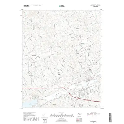
2019 Map of Wilkesboro
USGS Topo · Published 2019About this map
The Yadkin River and Reddies River converge at the heart of this North Carolina quadrangle, defining the development of North Wilkesboro and Wilkesboro. This 2019 survey shows the modern footprint of the area, where the Wilkes Community College campus and the Wilkes Co Airport reflect the region's contemporary role as a regional hub. Significant landmarks include Mountlawn Memorial Park and Mountain Park Cem, which alongside smaller burial grounds like Tarheel Cem and Saint Pauls Cem, provide essential data for local genealogical research.
Find a feature on this map
224 named features on this map. Tap any name to fly to it.
Don’t see what you’re looking for? This feature index may not catch every label — zoom into the map to look around manually.
Map Details
Editions of this 2019 Wilkesboro Map
This is the sole edition of this map. No revisions or reprints were ever made.
Other maps of this area

1889 · Wilkesboro
USGS Topo · 1:125,000

1891 · Wilkesboro
USGS Topo · 1:125,000

1953 · Winston-Salem
USGS Topo · 1:250,000

1955 · Winston-Salem
USGS Topo · 1:250,000

1962 · Winston-Salem
USGS Topo · 1:250,000
1966 · Gilreath
USGS Topo · 1:24,000

1966 · Roaring River
USGS Topo · 1:24,000
1966 · Boomer
USGS Topo · 1:24,000
1966 · Moravian Falls
USGS Topo · 1:24,000

1966 · Wilkesboro
USGS Topo · 1:24,000