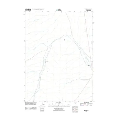
2012 Map of Wilkins
USGS Topo · Published 2012About this map
Thousand Springs Valley defines the arid character of this Elko County landscape, where water dictates the location of early settlements and transport routes. The small community of Wilkins serves as a primary point of interest, situated where several seasonal drainages converge in this high-desert basin. The map reveals a complex network of hydrologic features including Thousand Springs Creek, Cold Springs Creek, and Willow Creek, which emphasize the importance of water management in this region. The terrain is further marked by Red Point, a prominent natural landmark that overlooks the valley floor. Nearby, the settlement of Herrel and the winding course of Loomis Creek provide additional context for local historians and genealogists studying the rural development and ranching heritage of northeastern Nevada during the early twenty-first century.
Find a feature on this map
9 named features on this map. Tap any name to fly to it.
Don’t see what you’re looking for? This feature index may not catch every label — zoom into the map to look around manually.
Map Details
Editions of this 2012 Wilkins Map
This is the sole edition of this map. No revisions or reprints were ever made.
Other maps of this area

1955 · Wells
USGS Topo · 1:250,000

1958 · Wells
USGS Topo · 1:250,000

1961 · Wells
USGS Topo · 1:250,000

1968 · Wilkins
USGS Topo · 1:24,000

1968 · Melandco
USGS Topo · 1:24,000

1968 · Knoll Mountain
USGS Topo · 1:24,000

1968 · Summer Camp
USGS Topo · 1:24,000

1968 · Wine Cup Ranch
USGS Topo · 1:24,000
1968 · Wine Cup Ranch SW
USGS Topo · 1:24,000
1968 · Loomis Mtn
USGS Topo · 1:24,000