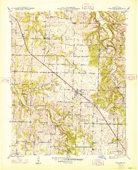
1948 Map of Willard
USGS Topo · Published 1948About this map
The St Louis San Francisco railroad corridor serves as the primary axis for this Greene County landscape, connecting the town of Willard to outlying communities like Pearl and Ritter. The terrain is defined by the winding course of the Little Sac River and its tributaries, including Mt Pleasant Branch and Clear Creek. This 1946 survey provides a clear view of a rural society organized around its townships and district schools, such as Flat Rock Sch and Wiley Sch. Of particular interest to local historians are the river crossings, with Hackney Mill Bridge and Knox Ford Bridge marking established transit points before modern infrastructure. Near the southeastern corner, the early footprint of the Springfield Airport appears, signaling the area's transition towards mid-century regional connectivity.
Find a feature on this map
38 named features on this map. Tap any name to fly to it.
Don’t see what you’re looking for? This feature index may not catch every label — zoom into the map to look around manually.
Map Details
Editions of this 1948 Willard Map
2 editions found
Other maps of this area

1884 · Springfield
USGS Topo · 1:125,000

1886 · Greenfield
USGS Topo · 1:125,000

1886 · Springfield
USGS Topo · 1:125,000

1888 · Greenfield
USGS Topo · 1:125,000

1919 · Halltown
USGS Topo · 1:62,500

1935 · Springfield
USGS Topo · 1:24,000

1936 · Brookline
USGS Topo · 1:24,000

1948 · Willard
USGS Topo · 1:24,000

1948 · Ebenezer
USGS Topo · 1:24,000

1954 · Springfield
USGS Topo · 1:250,000