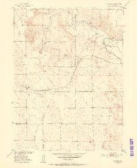
1951 Map of Willard
USGS Topo · Published 1952About this map
Willard sits at the intersection of the Chicago Burlington and Quincy railroad and the Sand Creek drainage, serving as a focal point for the surrounding dryland cattle and farming country. The landscape is defined by the Pawnee Hills and Pawnee Pass, where numerous windmills indicate the vital importance of groundwater in this high plains environment.
Find a feature on this map
20 named features on this map. Tap any name to fly to it.
Don’t see what you’re looking for? This feature index may not catch every label — zoom into the map to look around manually.
Map Details
Editions of this 1951 Willard Map
3 editions found
Other maps of this area

1951 · Willard
USGS Topo · 1:24,000

1951 · Messex
USGS Topo · 1:24,000

1951 · Antelope Springs
USGS Topo · 1:24,000

1951 · Wild Horse Lake
USGS Topo · 1:24,000

1951 · Atwood NE
USGS Topo · 1:24,000

1951 · Merino
USGS Topo · 1:24,000

1951 · Atwood
USGS Topo · 1:24,000

1954 · Sterling
USGS Topo · 1:250,000

1958 · Sterling
USGS Topo · 1:250,000

1971 · Messex
USGS Topo · 1:24,000