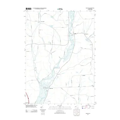
2013 Map of Willet
USGS Topo · Published 2013About this map
The Otselic River winds through the heart of this landscape, its expansive floodplains and wetlands defining the geography between Willet and Upper Lisle. This 2013 survey illustrates a quiet rural network of hamlets and crossroad settlements such as Texas Valley, Georgetown, and Penelope. The region's genealogy is well-documented through several burial sites, including Willet Village Cem and the Hazard Corners Cem in the east. Notable infrastructure includes the Upper Lisle Road Bridge and the Landers Corners Road Bridge, which provide critical crossings over the river and its associated marshlands. The terrain rises from the river valley toward landmarks like Irish Hill, with smaller water bodies such as Bloody Pond and Stump Pond dotting the uplands, reflecting a classic Upstate New York pattern of valley-bottom settlements and upland farms.
Find a feature on this map
91 named features on this map. Tap any name to fly to it.
Don’t see what you’re looking for? This feature index may not catch every label — zoom into the map to look around manually.
Map Details
Editions of this 2013 Willet Map
This is the sole edition of this map. No revisions or reprints were ever made.
Other maps of this area

1903 · Cortland
USGS Topo · 1:62,500

1903 · Harford
USGS Topo · 1:62,500

1904 · Greene
USGS Topo · 1:62,500

1904 · Pitcher
USGS Topo · 1:62,500

1906 · Catatonk
USGS Topo · 1:125,000

1943 · Cincinnatus
USGS Topo · 1:24,000

1943 · Pitcher
USGS Topo · 1:24,000
1944 · Pitcher
USGS Topo · 1:31,680
1944 · Mc Graw
USGS Topo · 1:31,680
1944 · Cincinnatus
USGS Topo · 1:31,680