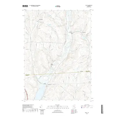
2019 Map of Willet
USGS Topo · Published 2019About this map
The Otselic River winds through the heart of the central New York countryside, shaping the valley where the small settlements of Willet and Upper Lisle are situated. This area, spanning the border between Cortland and Broome counties, remains defined by its steep hills and deep-cut stream valleys. The landscape is marked by numerous family-named landmarks such as Mooney Hill Rd and Witty Hill Rd, reflecting a long history of local land ownership. Significant water features like High Lake, Bloody Pond, and Stump Pond dot the higher elevations between the drainage of Merrill Creek and Gee Brook. For those researching local lineages, the map identifies several burial grounds including Texas Valley Cem, Willet Village Cem, and Hazard Corners Cem. The network of backroads, from Phalen Rd to Salisbury Rd, follows the contours of the drainage basins, connecting historic crossroads like Texas Valley and Georgetown.
Find a feature on this map
83 named features on this map. Tap any name to fly to it.
Don’t see what you’re looking for? This feature index may not catch every label — zoom into the map to look around manually.
Map Details
Editions of this 2019 Willet Map
This is the sole edition of this map. No revisions or reprints were ever made.
Other maps of this area

1903 · Cortland
USGS Topo · 1:62,500

1903 · Harford
USGS Topo · 1:62,500

1904 · Greene
USGS Topo · 1:62,500

1904 · Pitcher
USGS Topo · 1:62,500

1906 · Catatonk
USGS Topo · 1:125,000

1943 · Cincinnatus
USGS Topo · 1:24,000

1943 · Pitcher
USGS Topo · 1:24,000
1944 · Pitcher
USGS Topo · 1:31,680
1944 · Mc Graw
USGS Topo · 1:31,680
1944 · Cincinnatus
USGS Topo · 1:31,680