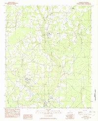
1982 Map of Williams
USGS Topo · Published 1982About this map
Williams and Smoaks anchor this corner of Colleton County, reflecting a landscape defined by the winding tributaries of the Little Salkehatchie River. The area's settlement pattern is closely tied to the low-lying drainage systems of Buckhead Creek and Deep Bottom Creek, where small crossroads communities like Smyly and Ruffin developed alongside a network of local roads and a prominent trans line.
Find a feature on this map
12 named features on this map. Tap any name to fly to it.
Don’t see what you’re looking for? This feature index may not catch every label — zoom into the map to look around manually.
Map Details
Editions of this 1982 Williams Map
This is the sole edition of this map. No revisions or reprints were ever made.
Other maps of this area

1918 · Walterboro
USGS Topo · 1:62,500

1919 · Cummings
USGS Topo · 1:62,500

1919 · Lodge
USGS Topo · 1:62,500

1920 · Lodge
USGS Topo · 1:48,000

1920 · St. George
USGS Topo · 1:48,000

1921 · Lodge
USGS Topo · 1:62,500

1921 · St. George
USGS Topo · 1:62,500

1943 · Lodge
USGS Topo · 1:62,500

1943 · Orangeburg
USGS Topo · 1:125,000

1943 · Cummings
USGS Topo · 1:62,500