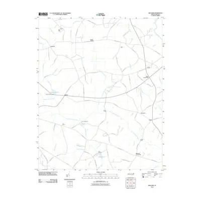
2010 Map of Williams
USGS Topo · Published 2010About this map
The Northeast Cape Fear River snakes through this rural corner of North Carolina, defining a landscape of agricultural crossroads and wetlands. In 2010, the area remained anchored by established rural settlements such as Hopewell, Indian Springs, and Pricetown. Water management and recreational use are evident at Williams Millpond and its associated Williams Millpond Dam, as well as Deavers Pond and Whitfields Pond. The map reveals a high density of named family-linked landmarks and crossroads, including Hines Crossroads, Gradys, and Blizzards Crossroads. Local heritage and community sites are well-documented, from the Pine View Cemetery and Jones Cemetery to youth organizations at Camp Tuscarora and Camp Jubilee. The presence of Halls Marsh and several named branches like Horsepen Branch and Wolfscrape Branch suggests the low-lying, well-watered nature of this coastal plain terrain.
Find a feature on this map
82 named features on this map. Tap any name to fly to it.
Don’t see what you’re looking for? This feature index may not catch every label — zoom into the map to look around manually.
Map Details
Editions of this 2010 Williams Map
This is the sole edition of this map. No revisions or reprints were ever made.
Other maps of this area

1953 · Rocky Mount
USGS Topo · 1:250,000

1953 · Raleigh
USGS Topo · 1:250,000

1954 · Rocky Mount
USGS Topo · 1:250,000

1954 · Raleigh
USGS Topo · 1:250,000

1957 · Goldsboro
USGS Topo · 1:62,500

1957 · Seven Springs
USGS Topo · 1:62,500

1974 · Southwest Goldsboro
USGS Topo · 1:24,000
1977 · Warsaw North
USGS Topo · 1:24,000
1977 · Mount Olive
USGS Topo · 1:24,000

1980 · Seven Springs
USGS Topo · 1:24,000