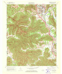
1969 Map of Williamsburg
USGS Topo · Published 1972About this map
Williamsburg serves as the focal point of this topographic study, situated along a prominent bend of the Cumberland River and hosting Cumberland College. The 1969 landscape is defined by the intersection of traditional river-and-rail routes with the modern development of Interstate 75, which cuts through the eastern portion of the quadrangle. The terrain transitions from the developed valley floor at Savoy and Balltown into the dense woodlands of the Daniel Boone National Forest to the west. Evidence of local industry is visible through numerous mines, strip mines, and gas wells scattered across the ridgelines of Jellico Mountain and Hog Owl Mountain. Community centers like White Oak Cem & Ch and New Zion Ch highlight the era's rural settlement patterns, while the Louisville and Nashville railroad tracks parallel the Clear Fork through towns like Pleasant View and Mountain Ash.
Find a feature on this map
72 named features on this map. Tap any name to fly to it.
Don’t see what you’re looking for? This feature index may not catch every label — zoom into the map to look around manually.
Map Details
Editions of this 1969 Williamsburg Map
2 editions found
Other maps of this area

1890 · Williamsburg
USGS Topo · 1:125,000

1894 · Williamsburg
USGS Topo · 1:125,000

1952 · Wofford
USGS Topo · 1:24,000

1952 · Saxton
USGS Topo · 1:24,000

1952 · Hollyhill
USGS Topo · 1:24,000

1952 · Rockholds
USGS Topo · 1:24,000

1952 · Cumberland Falls
USGS Topo · 1:24,000

1952 · Williamsburg
USGS Topo · 1:24,000
1953 · Jellico West
USGS Topo · 1:24,000
1953 · Jellico East
USGS Topo · 1:24,000