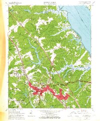
1965 Map of Williamsburg
USGS Topo · Published 1966About this map
Williamsburg and the surrounding Tidewater landscape appear in the mid-1960s as a complex mix of historic preservation, academic growth, and military installation. The Historical Area sits at the heart of the city, where researchers can identify landmarks like the Governor's Palace and The Capitol, alongside the sprawling campus of the College of William and Mary. The era's expansion is evident in the residential developments branching out from the center, such as Indigo Terrace, Canterbury Hills, and Plantation Heights.
Find a feature on this map
95 named features on this map. Tap any name to fly to it.
Don’t see what you’re looking for? This feature index may not catch every label — zoom into the map to look around manually.
Map Details
Editions of this 1965 Williamsburg Map
4 editions found
Other maps of this area

1906 · Williamsburg
USGS Topo · 1:62,500

1907 · Yorktown
USGS Topo · 1:62,500

1917 · Toano
USGS Topo · 1:62,500

1918 · Toano
USGS Topo · 1:62,500

1919 · Surry
USGS Topo · 1:62,500

1943 · Yorktown
USGS Topo · 1:62,500

1943 · Richmond
USGS Topo · 1:250,000

1944 · Yorktown
USGS Topo · 1:24,000

1949 · Richmond
USGS Topo · 1:250,000

1950 · Cobham Bay
USGS Topo · 1:24,000