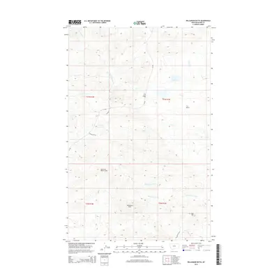
2014 Map of Williamson Butte
USGS Topo · Published 2014About this map
Williamson Butte stands as a prominent landmark in this section of Blaine County, where the high plains are deeply incised by a complex network of coulees and creeks. The landscape is defined by its water management and drainage patterns, featuring the T U Reservoir and the extensive Bullwhacker Coulee. Transport through this open range is facilitated by early routes such as Lloyd Rd and Golden Valley Rd, which cross the drainage of Cow Cr at the Cow Creek Bridge. The topography reveals the transition from flat benches like T U Bench to the more varied terrain around Goat Mtn. This area's ranching and resource history is etched into its naming conventions, from the industrial suggestion of Coal Mine Coulee to the various forks of the perennial and seasonal waterways that sustain this part of the northern Missouri River watershed.
Find a feature on this map
20 named features on this map. Tap any name to fly to it.
Don’t see what you’re looking for? This feature index may not catch every label — zoom into the map to look around manually.
Map Details
Editions of this 2014 Williamson Butte Map
This is the sole edition of this map. No revisions or reprints were ever made.
Other maps of this area

1953 · Havre
USGS Topo · 1:250,000

1954 · Lewistown
USGS Topo · 1:250,000

1956 · Maddux
USGS Topo · 1:62,500

1956 · Rattlesnake
USGS Topo · 1:62,500

1957 · Havre
USGS Topo · 1:250,000

1958 · Havre
USGS Topo · 1:250,000

1959 · Lewistown
USGS Topo · 1:250,000
1985 · Nolan Reservoir
USGS Topo · 1:24,000
1985 · Sandpiper Reservoir
USGS Topo · 1:24,000
1985 · Saddle Rock
USGS Topo · 1:24,000