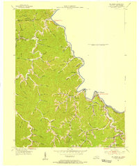
1954 Map of Williamson
USGS Topo · Published 1955About this map
Tug Fork carves the boundary between Pike County and Mingo County in this mid-century portrait of the Kentucky-West Virginia borderlands. The landscape is defined by a dense network of mountain hollows and branches, where small communities like South Williamson and Belfry developed alongside the Norfolk and Western railroad. Significant institutional presence is visible through the Memorial Medical Center and Tug Valley Hospital, serving a region marked by rural schooling at Turkey Creek Sch and Bent Branch Sch. Local topography is detailed through family-named landmarks such as Negro Hol, Indian Grave Hol, and Groundhog Hol. Industrial activity is represented by a Gravel Pit near Goody, while the religious life of the mountain gaps is anchored by Point Truth Ch and Old Pond Ch.
Find a feature on this map
82 named features on this map. Tap any name to fly to it.
Don’t see what you’re looking for? This feature index may not catch every label — zoom into the map to look around manually.
Map Details
Editions of this 1954 Williamson Map
2 editions found
Other maps of this area

1887 · Warfield
USGS Topo · 1:125,000

1891 · Warfield
USGS Topo · 1:125,000

1909 · Matewan
USGS Topo · 1:48,000

1910 · Holden
USGS Topo · 1:48,000

1910 · Naugatuck
USGS Topo · 1:48,000

1912 · Naugatuck
USGS Topo · 1:62,500

1912 · Holden
USGS Topo · 1:62,500

1915 · Williamson
USGS Topo · 1:48,000

1915 · Naugatuck
USGS Topo · 1:48,000

1915 · Matewan
USGS Topo · 1:48,000