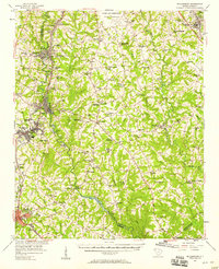
1957 Map of Williamston
USGS Topo · Published 1958About this map
Industrial and rural life intersect along the Saluda River in this mid-century survey of the South Carolina upstate. The textile heritage of the region is evident at Pelzer Mills Dam, which powered the riverside communities of Pelzer and West Pelzer. To the west, Williamston and Belton serve as significant rail hubs connected by the Southern and Piedmont and Northern lines. The landscape is densely populated with community landmarks, including numerous small country churches like Cedar Shoals Ch and Standing Springs Ch, alongside educational centers such as Palmetto High Sch.
Find a feature on this map
97 named features on this map. Tap any name to fly to it.
Don’t see what you’re looking for? This feature index may not catch every label — zoom into the map to look around manually.
Map Details
Editions of this 1957 Williamston Map
2 editions found

Other maps of this area

1888 · Pickens
USGS Topo · 1:125,000

1892 · Abbeville
USGS Topo · 1:125,000

1893 · Elberton
USGS Topo · 1:125,000

1894 · Pickens
USGS Topo · 1:125,000

1935 · Greer
USGS Topo · 1:48,000

1935 · Greenville
USGS Topo · 1:48,000

1938 · Greenville
USGS Topo · 1:62,500

1938 · Greer
USGS Topo · 1:62,500

1954 · Greenville
USGS Topo · 1:250,000

1957 · Fountain Inn
USGS Topo · 1:62,500