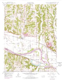
1949 Map of Williamstown
USGS Topo · Published 1978About this map
Williamstown sits at the center of this 1940s landscape, serving as a hub for the surrounding rural communities of Rural, Sarcoxie, and Lecompton. The area is defined by the sweeping course of the Kansas River and the complex drainage of Stone House Creek, Kentucky Creek, and Buck Creek. Significant infrastructure from the mid-century is evident, including the Union Pacific and Atchison Topeka and Santa Fe railroads, which parallel the river valley. The map reveals a high density of rural educational and social landmarks, such as Clover Hill Sch, Dean Sch, and Sunnyside Sch. The presence of the Old Indian Bdy line across the northern sections provides a notable connection to earlier territorial history, while features like Lake View Lake and various gravel or sand pits suggest the localized industries of the Jefferson County and Douglas County borderlands.
Find a feature on this map
34 named features on this map. Tap any name to fly to it.
Don’t see what you’re looking for? This feature index may not catch every label — zoom into the map to look around manually.
Map Details
Editions of this 1949 Williamstown Map
3 editions found
Other maps of this area

1885 · Lawrence
USGS Topo · 1:125,000

1886 · Oskaloosa
USGS Topo · 1:125,000

1888 · Oskaloosa
USGS Topo · 1:125,000

1889 · Lawrence
USGS Topo · 1:125,000

1894 · Oskaloosa
USGS Topo · 1:125,000

1947 · Lawrence
USGS Topo · 1:250,000

1949 · Williamstown
USGS Topo · 1:24,000

1949 · Perry
USGS Topo · 1:24,000

1950 · Perry
USGS Topo · 1:24,000

1950 · Kansas City
USGS Topo · 1:250,000