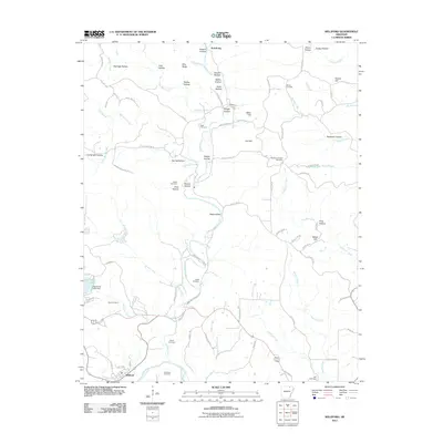
2011 Map of Williford
USGS Topo · Published 2011About this map
Williford sits at the southern edge of this Arkansas landscape, where the Spring River winds through the hills. This 2011 survey reveals a territory defined by a dense network of named hollows and ridges, illustrating how the topography has dictated local naming conventions and land use for generations. The area's genealogical depth is evident in the high concentration of small family and community burial grounds, such as the Bradford Chapel Cemetery and Wicker Cemetery, which are tucked away among the drainage basins of Martins Creek and Ferguson Creek. To the west, the Vagabond Lake Dam represents a more modern hydrological modification to the terrain. From the northern settlement of Armstrong down to the creek-side hollows like Prewitt Hollow and Deadman Hollow, the map documents a rural Ozark foothills community where the relationship between the winding county roads and the natural watercourses remains central to the local geography.
Find a feature on this map
88 named features on this map. Tap any name to fly to it.
Don’t see what you’re looking for? This feature index may not catch every label — zoom into the map to look around manually.
Map Details
Editions of this 2011 Williford Map
This is the sole edition of this map. No revisions or reprints were ever made.
Other maps of this area

1934 · Powhatan
USGS Topo · 1:62,500

1935 · Powhatan
USGS Topo · 1:62,500

1957 · Poplar Bluff
USGS Topo · 1:250,000

1959 · Poplar Bluff
USGS Topo · 1:250,000

1960 · Poplar Bluff
USGS Topo · 1:250,000

1966 · Ravenden Springs
USGS Topo · 1:24,000
1966 · Imboden
USGS Topo · 1:24,000

1968 · Hardy
USGS Topo · 1:24,000
1968 · Hardy NE
USGS Topo · 1:24,000
1968 · Wirth
USGS Topo · 1:24,000