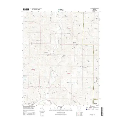
2014 Map of Williford
USGS Topo · Published 2014About this map
Armstrong and Williford anchor this northeastern Arkansas landscape, where the Ozark foothills meet a complex network of creeks and hollows. The Spring River winds through the southwestern corner, joined by tributaries like Martins Creek and Dayberry Cr, carving out a terrain defined by landmarks such as Beard Hill, Levi Hill, and Bear Bluff. This topographic study reveals a deeply settled rural interior marked by a high density of family and community burial grounds, including the Bradford Cemetery, Ratliff Cem, and Wicker Cem.
Find a feature on this map
102 named features on this map. Tap any name to fly to it.
Don’t see what you’re looking for? This feature index may not catch every label — zoom into the map to look around manually.
Map Details
Editions of this 2014 Williford Map
This is the sole edition of this map. No revisions or reprints were ever made.
Other maps of this area

1934 · Powhatan
USGS Topo · 1:62,500

1935 · Powhatan
USGS Topo · 1:62,500

1957 · Poplar Bluff
USGS Topo · 1:250,000

1959 · Poplar Bluff
USGS Topo · 1:250,000

1960 · Poplar Bluff
USGS Topo · 1:250,000

1966 · Ravenden Springs
USGS Topo · 1:24,000
1966 · Imboden
USGS Topo · 1:24,000

1968 · Hardy
USGS Topo · 1:24,000
1968 · Hardy NE
USGS Topo · 1:24,000
1968 · Wirth
USGS Topo · 1:24,000