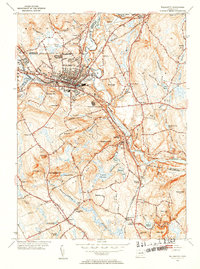
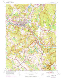
1953 Map of Willimantic
USGS Topo · Published 1954About this map
Industrial and rail activity converges at Willimantic, where the Natchaug River and Tenmile River meet to form the Shetucket River. This early 1950s survey documents a landscape defined by its river-valley infrastructure, showing the New York New Haven and Hartford and Central Vermont rail lines threading through the hills. The terrain is marked by numerous family-named peaks such as Hosmer Mtn, Gates Hill, and Kick Hill, interspersed with water bodies like Mansfield Hollow Reservoir and Eatons Pond. Outside the primary urban center, the map reveals a network of smaller communities including South Windham, North Franklin, and Conantville. Genealogists will find value in the placement of rural landmarks like St Joseph Cem, Trumbull Cem, and several local schools including Pleasure Hill Sch and Cooley Hill Sch, which served the scattered farmsteads and riverside settlements of the era.
Find a feature on this map
69 named features on this map. Tap any name to fly to it.
Don’t see what you’re looking for? This feature index may not catch every label — zoom into the map to look around manually.
Map Details
Editions of this 1953 Willimantic Map
5 editions found
Other maps of this area

1892 · Woodstock
USGS Topo · 1:62,500

1892 · Tolland
USGS Topo · 1:62,500

1892 · Norwich
USGS Topo · 1:62,500

1892 · Gilead
USGS Topo · 1:62,500

1921 · Tolland
USGS Topo · 1:62,500

1921 · Woodstock
USGS Topo · 1:62,500

1943 · Fitchville
USGS Topo · 1:31,680

1944 · South Coventry
USGS Topo · 1:31,680
1944 · Hampton
USGS Topo · 1:31,680

1944 · Columbia
USGS Topo · 1:31,680