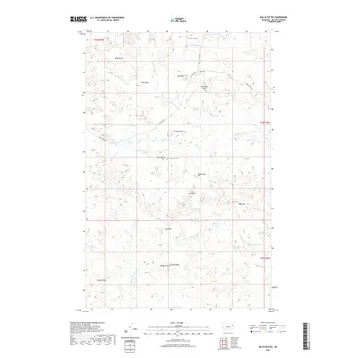
2020 Map of Willis Buttes
USGS Topo · Published 2020About this map
Willis Buttes and a series of prominent high points dominate this McCone County landscape, where the high plains break into complex coulees and divides. The drainage pattern is defined by Shade Cr and its northern and southern prongs, which are managed by a network of upland water catchments including Jays Reservoir, Goose Island Reservoir, and Hell Gate Reservoir. These scattered reservoirs and springs, such as Horsford Spring and Alecs Springs, suggest a ranching economy reliant on carefully distributed water sources across the semi-arid terrain. Named landmarks like Bald Butte, Teton Butte, and Vanderhoof Hill provide essential orientation markers, while the Bonin Divide in the southwest marks the separation of local watersheds. Transportation is limited to remote corridors like Maxwell Hill Rd and Shade Creek Rd, reflecting the low-density, wide-open character of this part of Montana.
Find a feature on this map
42 named features on this map. Tap any name to fly to it.
Don’t see what you’re looking for? This feature index may not catch every label — zoom into the map to look around manually.
Map Details
Editions of this 2020 Willis Buttes Map
This is the sole edition of this map. No revisions or reprints were ever made.
Other maps of this area

1954 · Jordan
USGS Topo · 1:250,000

1954 · Glendive
USGS Topo · 1:250,000

1956 · Jordan
USGS Topo · 1:250,000

1957 · Glendive
USGS Topo · 1:250,000

1958 · Jordan
USGS Topo · 1:250,000

1958 · Glendive
USGS Topo · 1:250,000

1964 · Jordan
USGS Topo · 1:250,000

1973 · Crow Springs
USGS Topo · 1:24,000
1973 · Willis Buttes
USGS Topo · 1:24,000
1973 · Pasture Creek
USGS Topo · 1:24,000