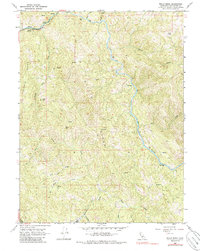
1966 Map of Willis Ridge
USGS Topo · Published 1986About this map
The Northwestern Pacific railroad tracks wind through the canyon of Outlet Creek in this mid-1960s study of the Mendocino highlands. The settlement at Farley serves as a lone point of habitation in a landscape dominated by the sharp elevation changes of Salmon Ridge and Willis Ridge. Water is the defining force here, from the broad bends of the Eel River to the smaller tributaries like Tomki Creek and Wheelbarrow Creek that carve the interior slopes.
Find a feature on this map
27 named features on this map. Tap any name to fly to it.
Don’t see what you’re looking for? This feature index may not catch every label — zoom into the map to look around manually.
Map Details
Editions of this 1966 Willis Ridge Map
3 editions found
Other maps of this area

1922 · Willits
USGS Topo · 1:62,500

1929 · Eden Valley
USGS Topo · 1:62,500

1942 · Willits
USGS Topo · 1:62,500

1943 · Pomo
USGS Topo · 1:62,500

1944 · Willits
USGS Topo · 1:62,500

1951 · Laytonville
USGS Topo · 1:62,500

1952 · Eden Valley
USGS Topo · 1:62,500

1957 · Ukiah
USGS Topo · 1:250,000

1960 · Ukiah
USGS Topo · 1:250,000

1960 · Potter Valley
USGS Topo · 1:62,500