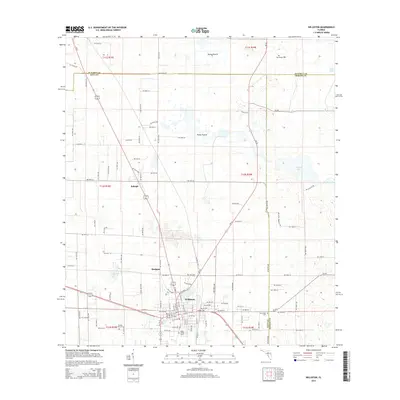
2015 Map of Williston
USGS Topo · Published 2015About this map
Williston serves as the primary hub of this 2015 survey, situated at the convergence of several regional transit corridors. The landscape is characterized by its internal drainage and prairie formations, such as Horse Prairie and Priest Prairie, which punctuate the low-lying terrain. To the north, the small settlement of Raleigh sits along the SR 45 corridor, illustrating the linear development patterns common in this part of Florida.
Find a feature on this map
107 named features on this map. Tap any name to fly to it.
Don’t see what you’re looking for? This feature index may not catch every label — zoom into the map to look around manually.
Map Details
Editions of this 2015 Williston Map
This is the sole edition of this map. No revisions or reprints were ever made.
Other maps of this area

1890 · Arredondo
USGS Topo · 1:62,500

1892 · Arredondo
USGS Topo · 1:62,500

1894 · Arredondo
USGS Topo · 1:62,500

1895 · Williston
USGS Topo · 1:62,500

1954 · Gainesville
USGS Topo · 1:250,000

1955 · Bronson NE
USGS Topo · 1:24,000

1955 · Bronson SE
USGS Topo · 1:24,000
1957 · Bronson SE
USGS Topo · 1:25,000

1958 · Gainesville
USGS Topo · 1:250,000

1959 · Gainesville
USGS Topo · 1:250,000