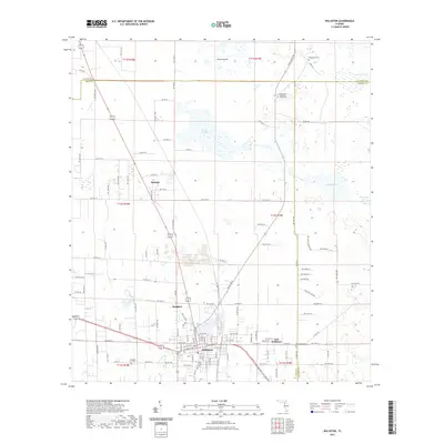
2021 Map of Williston
USGS Topo · Published 2021About this map
Williston serves as the focal point of this North Central Florida landscape where the borders of Levy, Alachua, and Marion counties converge. The 2021 survey reveals a complex grid of rural routes and residential streets, particularly around East Williston and the smaller settlements of Raleigh and Hodgson. Genealogical interest is concentrated in several distinct burial grounds, including the Willis Family Cem and the Wacahoota Methodist Church Cem, which speak to the area's deep-rooted family histories and early religious foundations.
Find a feature on this map
105 named features on this map. Tap any name to fly to it.
Don’t see what you’re looking for? This feature index may not catch every label — zoom into the map to look around manually.
Map Details
Editions of this 2021 Williston Map
This is the sole edition of this map. No revisions or reprints were ever made.
Other maps of this area

1890 · Arredondo
USGS Topo · 1:62,500

1892 · Arredondo
USGS Topo · 1:62,500

1894 · Arredondo
USGS Topo · 1:62,500

1895 · Williston
USGS Topo · 1:62,500

1954 · Gainesville
USGS Topo · 1:250,000

1955 · Bronson NE
USGS Topo · 1:24,000

1955 · Bronson SE
USGS Topo · 1:24,000
1957 · Bronson SE
USGS Topo · 1:25,000

1958 · Gainesville
USGS Topo · 1:250,000

1959 · Gainesville
USGS Topo · 1:250,000