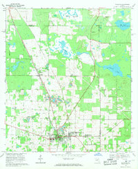
1969 Map of Williston
USGS Topo · Published 1971About this map
The town of Williston anchors this 1960s survey, showing a landscape defined by limestone extraction and diverse agricultural boundaries in Levy County. The regional economy is anchored by numerous mining sites, including an Abandoned Quarry and several active Quarries, while the Seaboard Coast Line railroad facilitates transport through settlements like Raleigh and Hodgson. Community life is traced through scattered rural institutions such as Wacahoota Ch, Nolan Ch, and the Vocational Sch near the town center. The topography is notable for its numerous prairies and sinkholes, including Horse Prairie, Priest Prairie, and the water-filled Blue Grotto. Historical land divisions are marked by the Arredondo Grant Boundary, reflecting old Spanish land grants that still influenced property lines and road placements well into the twentieth century.
Find a feature on this map
39 named features on this map. Tap any name to fly to it.
Don’t see what you’re looking for? This feature index may not catch every label — zoom into the map to look around manually.
Map Details
Editions of this 1969 Williston Map
2 editions found
Other maps of this area

1890 · Arredondo
USGS Topo · 1:62,500

1892 · Arredondo
USGS Topo · 1:62,500

1894 · Arredondo
USGS Topo · 1:62,500

1895 · Williston
USGS Topo · 1:62,500

1954 · Gainesville
USGS Topo · 1:250,000

1955 · Bronson NE
USGS Topo · 1:24,000

1955 · Bronson SE
USGS Topo · 1:24,000
1957 · Bronson SE
USGS Topo · 1:25,000

1958 · Gainesville
USGS Topo · 1:250,000

1959 · Gainesville
USGS Topo · 1:250,000