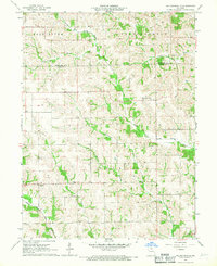
1966 Map of Willmathsville
USGS Topo · Published 1967About this map
Willmathsville and the surrounding rural landscape of Adair and Schuyler Counties are defined by a complex network of waterways that shaped mid-20th-century settlement. The Salt River divides into its northern and southern forks across the western half of the map, while the South Fork Fabius River and the North Fork South Fabius River drain the eastern hills. This 1966 field-checked survey illustrates a traditional Missouri agricultural pattern where community life centered around small crossroads like Sperry and Adair. Local history is deeply embedded in the land through markers like Trinity Ch and several burial grounds, including Bridge Creek Cem and Richardson Cem. The presence of Cottonwood Branch and Tawaninny Branch highlights the intricate drainage system of Independence and Clay townships, providing a clear record of the area's geography before modern development changed the local road and waterway intersections.
Find a feature on this map
21 named features on this map. Tap any name to fly to it.
Don’t see what you’re looking for? This feature index may not catch every label — zoom into the map to look around manually.
Map Details
Editions of this 1966 Willmathsville Map
This is the sole edition of this map. No revisions or reprints were ever made.
Other maps of this area

1903 · Edina
USGS Topo · 1:125,000

1911 · Queen City
USGS Topo · 1:62,500

1913 · Queen City
USGS Topo · 1:62,500

1938 · Kirksville
USGS Topo · 1:62,500

1940 · Kirksville
USGS Topo · 1:62,500

1954 · Centerville
USGS Topo · 1:250,000

1957 · Centerville
USGS Topo · 1:250,000

1958 · Centerville
USGS Topo · 1:250,000

1965 · Downing NW
USGS Topo · 1:24,000

1966 · Brashear
USGS Topo · 1:24,000