
1951 Map of Willow Creek NE
USGS Topo · Published 1979About this map
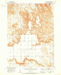
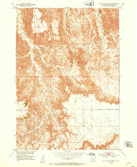
The Pine Ridge Indian Reservation landscape is defined by the stark transition from high tablelands to deeply eroded drainage basins. The prominent Cuny Table dominates the northern portion of the sheet, providing a level plateau that drops sharply into a network of canyons and creek beds. This terrain dictated the early movement and land use patterns within the reservation, as seen in the way East Horse Creek and West Horse Creek wind through the dissected topography. Compiled from 1948 aerial photography and revised in the late 1970s, this survey highlights the intricate hydrology of the region, including the headwaters of Willow Creek and the bifurcated branches of East Fork Mule Creek and West Fork Mule Creek. The map serves as a detailed record of the natural breaks and land divisions within this portion of South Dakota's interior.
Find a feature on this map
11 named features on this map. Tap any name to fly to it.
Don’t see what you’re looking for? This feature index may not catch every label — zoom into the map to look around manually.
Map Details
Editions of this 1951 Willow Creek NE Map
2 editions found
Other maps of this area
1950 · Cuny Table East
USGS Topo · 1:24,000

1951 · Rockyford SW
USGS Topo · 1:24,000
1951 · Willow Creek NW
USGS Topo · 1:24,000

1951 · Rockyford NW
USGS Topo · 1:24,000
1951 · Willow Creek NE
USGS Topo · 1:24,000
1951 · Red Shirt SW
USGS Topo · 1:24,000
1951 · Cuny Table West
USGS Topo · 1:24,000

1955 · Hot Springs
USGS Topo · 1:250,000

1967 · Willow Creek SW
USGS Topo · 1:24,000

1967 · Willow Creek
USGS Topo · 1:24,000