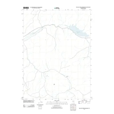
2012 Map of Willow Creek Reservoir
USGS Topo · Published 2012About this map
Willow Creek Reservoir sits as the central landmark of this high-desert landscape in Elko County, gathering the waters of Willow Creek as it flows through a terrain defined by subtle water sources and prominent geological markers. The area's reliance on intermittent and perennial water is evident in the cluster of vital springs, including Ivanhoe Spring, Buttercup Spring, and Antelope Spring, which likely supported livestock and early explorers in this arid region. The topography rises toward Big Butte and spreads across the open Ivanhoe Flat, illustrating a typical Great Basin drainage pattern where small creeks like North Antelope Creek and Ivanhoe Creek navigate through wide flats. This 2012 survey by the U.S. Geological Survey captures the modern configuration of the reservoir and the network of backroads that crisscross the high plains of northeastern Nevada.
Find a feature on this map
11 named features on this map. Tap any name to fly to it.
Don’t see what you’re looking for? This feature index may not catch every label — zoom into the map to look around manually.
Map Details
Editions of this 2012 Willow Creek Reservoir Map
This is the sole edition of this map. No revisions or reprints were ever made.
Other maps of this area

1955 · McDermitt
USGS Topo · 1:250,000

1956 · Mt. Blitzen
USGS Topo · 1:62,500

1959 · McDermitt
USGS Topo · 1:250,000

1965 · Willow Creek Reservoir
USGS Topo · 1:24,000

1965 · Squaw Valley Ranch
USGS Topo · 1:24,000

1965 · Rock Creek Ranch
USGS Topo · 1:24,000
1965 · Willow Creek Reservoir SE
USGS Topo · 1:24,000
1970 · China Camp
USGS Topo · 1:24,000
1970 · Santa Renia Fields
USGS Topo · 1:24,000

1973 · Little Rock Creek
USGS Topo · 1:24,000