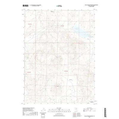
2018 Map of Willow Creek Reservoir
USGS Topo · Published 2018About this map
Willow Creek Reservoir sits at the northern edge of this high-desert landscape in Elko County, surrounded by a complex network of ridges and flats. The terrain is defined by dramatic elevation shifts, rising from the broad Ivanhoe Flat toward the southern peaks of the Santa Renia Mountains. This 2018 survey reveals a landscape where water is a vital but isolated resource, marked by scattered water sources like Hot Creek Spring and Ivanhoe Spring.
Find a feature on this map
14 named features on this map. Tap any name to fly to it.
Don’t see what you’re looking for? This feature index may not catch every label — zoom into the map to look around manually.
Map Details
Editions of this 2018 Willow Creek Reservoir Map
This is the sole edition of this map. No revisions or reprints were ever made.
Other maps of this area

1955 · McDermitt
USGS Topo · 1:250,000

1956 · Mt. Blitzen
USGS Topo · 1:62,500

1959 · McDermitt
USGS Topo · 1:250,000

1965 · Willow Creek Reservoir
USGS Topo · 1:24,000

1965 · Squaw Valley Ranch
USGS Topo · 1:24,000

1965 · Rock Creek Ranch
USGS Topo · 1:24,000
1965 · Willow Creek Reservoir SE
USGS Topo · 1:24,000
1970 · China Camp
USGS Topo · 1:24,000
1970 · Santa Renia Fields
USGS Topo · 1:24,000

1973 · Little Rock Creek
USGS Topo · 1:24,000