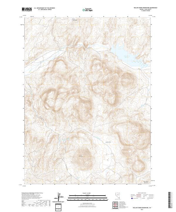
2021 Map of Willow Creek Reservoir
USGS Topo · Published 2021About this map
Willow Creek Reservoir dominates the northeastern corner of this high-desert landscape in Elko County, where the topography transitions from the high elevations of Willow Creek Ridge down toward the southern Santa Renia Mountains. The presence of Hot Creek Spring, Ivanhoe Spring, and Antelope Spring highlights the critical importance of reliable water sources in this arid ranching and mining country.
Find a feature on this map
19 named features on this map. Tap any name to fly to it.
Don’t see what you’re looking for? This feature index may not catch every label — zoom into the map to look around manually.
Map Details
Editions of this 2021 Willow Creek Reservoir Map
This is the sole edition of this map. No revisions or reprints were ever made.
Other maps of this area

1955 · McDermitt
USGS Topo · 1:250,000

1956 · Mt. Blitzen
USGS Topo · 1:62,500

1959 · McDermitt
USGS Topo · 1:250,000

1965 · Willow Creek Reservoir
USGS Topo · 1:24,000

1965 · Squaw Valley Ranch
USGS Topo · 1:24,000

1965 · Rock Creek Ranch
USGS Topo · 1:24,000
1965 · Willow Creek Reservoir SE
USGS Topo · 1:24,000
1970 · China Camp
USGS Topo · 1:24,000
1970 · Santa Renia Fields
USGS Topo · 1:24,000

1973 · Little Rock Creek
USGS Topo · 1:24,000