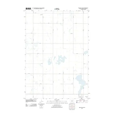
2012 Map of Willow Lake
USGS Topo · Published 2012About this map
Willow Lake and the smaller Mud Lake dominate the southeastern landscape of this Clark County quadrangle. The terrain is defined by its agricultural grid and intermittent prairie wetlands, where Pearl Cr and Redstone Cr meander through the western sections. In the northwestern corner, West Merton Cem serves as a significant local genealogical landmark, reflecting the early settlement history of Merton Township. The southern edge of the map shows the transition into more developed infrastructure near the town site, including the Willow Lake Airport and a coordinated street system featuring Jackson St and Grant St. This 2012 survey captures the modern rural character of the region, where legacy section-line roads like 424th Ave and 183rd St facilitate a vast network of family farms and water management sites.
Find a feature on this map
24 named features on this map. Tap any name to fly to it.
Don’t see what you’re looking for? This feature index may not catch every label — zoom into the map to look around manually.
Map Details
Editions of this 2012 Willow Lake Map
This is the sole edition of this map. No revisions or reprints were ever made.
Other maps of this area

1953 · Watertown
USGS Topo · 1:250,000

1958 · Watertown
USGS Topo · 1:250,000

1973 · Carpenter SE
USGS Topo · 1:24,000

1973 · Willow Lake
USGS Topo · 1:24,000

1973 · Clark South
USGS Topo · 1:24,000

1973 · Vienna West
USGS Topo · 1:24,000
1973 · Cherry Lake
USGS Topo · 1:24,000

1973 · Naples
USGS Topo · 1:24,000
1973 · Willow Lake SW
USGS Topo · 1:24,000
1973 · Raymond SE
USGS Topo · 1:24,000