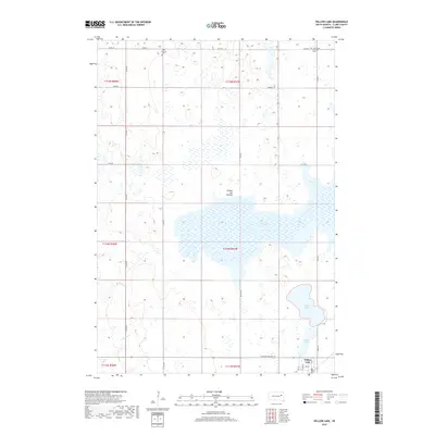
2017 Map of Willow Lake
USGS Topo · Published 2017About this map
Coteau des Prairies defines the rolling upland landscape of Clark County in this 2017 survey, characterized by its significant glacial wetland basins. The town of Willow Lake serves as the primary settlement, situated at the intersection of S Dakota Highway 28 and Grant St. This area is punctuated by substantial water bodies including the large Dry Lake Number Two, the namesake Willow Lake, and Mud Lake, illustrating the complex terminal moraine drainage patterns of the region. Local history and genealogy are anchored by rural landmarks such as West Merton Cem and Good Hope Lutheran Cem, which remain as permanent fixtures in the agricultural grid. The drainage network is further detailed by the seasonal flows of Pearl Cr and Redstone Cr, which thread through the section lines of the Public Land Survey System.
Find a feature on this map
24 named features on this map. Tap any name to fly to it.
Don’t see what you’re looking for? This feature index may not catch every label — zoom into the map to look around manually.
Map Details
Editions of this 2017 Willow Lake Map
This is the sole edition of this map. No revisions or reprints were ever made.
Other maps of this area

1953 · Watertown
USGS Topo · 1:250,000

1958 · Watertown
USGS Topo · 1:250,000

1973 · Carpenter SE
USGS Topo · 1:24,000

1973 · Willow Lake
USGS Topo · 1:24,000

1973 · Clark South
USGS Topo · 1:24,000

1973 · Vienna West
USGS Topo · 1:24,000
1973 · Cherry Lake
USGS Topo · 1:24,000

1973 · Naples
USGS Topo · 1:24,000
1973 · Willow Lake SW
USGS Topo · 1:24,000
1973 · Raymond SE
USGS Topo · 1:24,000