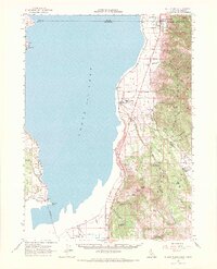
1962 Map of Willow Ranch
USGS Topo · Published 1972About this map
Goose Lake dominates this 1962 landscape, straddling the high desert border between California and Oregon. The eastern shore serves as a vital corridor where the Southern Pacific railroad and local highways connect the small timber and ranching settlements of Willow Ranch and New Pine Creek. This era of the early 1960s highlights the region's industrial and cultural foundations, from the Sawmill and Willow Ranch Cem to the New Pine Creek Sch near the state line.
Find a feature on this map
63 named features on this map. Tap any name to fly to it.
Don’t see what you’re looking for? This feature index may not catch every label — zoom into the map to look around manually.
Map Details
Editions of this 1962 Willow Ranch Map
2 editions found
Other maps of this area

1886 · Alturas
USGS Topo · 1:250,000

1892 · Alturas
USGS Topo · 1:250,000

1954 · Alturas
USGS Topo · 1:250,000

1955 · Klamath Falls
USGS Topo · 1:250,000

1958 · Alturas
USGS Topo · 1:250,000

1958 · Klamath Falls
USGS Topo · 1:250,000

1962 · Alturas
USGS Topo · 1:250,000

1962 · Davis Creek
USGS Topo · 1:62,500

1962 · Big Sage Reservoir
USGS Topo · 1:62,500

1962 · Willow Ranch
USGS Topo · 1:62,500