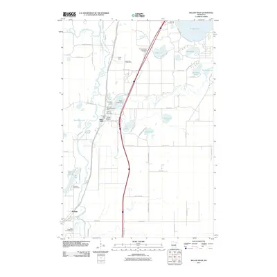
2010 Map of Willow River
USGS Topo · Published 2010About this map
The Willow River and Kettle River define this Pine County landscape, converging near the settlements of Willow River and Rutledge. At this time in 2010, the area shows a distinct transition between riverside habitation and recreational land use, featuring numerous campgrounds like Willow River Camp and Edelweiss Campground. The map documents critical local infrastructure, including the West Fork Desmoines River Dam and the Willow River Lookout Tower, which stands as a landmark for forest management. Genealogists will find several burial sites recorded, including Saint Mary's Catholic Cemetery and the Willow River City Cemetery. The presence of the Willard Munger Trl following the old rail corridor highlights the region's shift toward modern trail-based recreation while preserving its historical transport routes.
Find a feature on this map
70 named features on this map. Tap any name to fly to it.
Don’t see what you’re looking for? This feature index may not catch every label — zoom into the map to look around manually.
Map Details
Editions of this 2010 Willow River Map
This is the sole edition of this map. No revisions or reprints were ever made.
Other maps of this area

1953 · Duluth
USGS Topo · 1:250,000

1958 · Duluth
USGS Topo · 1:250,000

1961 · Sandstone
USGS Topo · 1:62,500

1961 · Moose Lake
USGS Topo · 1:62,500

1962 · Bruno
USGS Topo · 1:62,500

1962 · Cloverdale
USGS Topo · 1:62,500

1980 · Sandstone
USGS Topo · 1:100,000
1981 · Askov Lookout Tower
USGS Topo · 1:24,000

1981 · Willow River
USGS Topo · 1:24,000

1981 · Kettle River
USGS Topo · 1:24,000