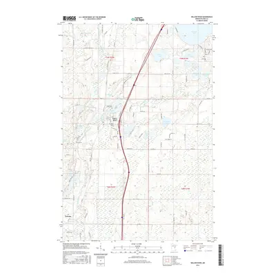
2016 Map of Willow River
USGS Topo · Published 2016About this map
The Kettle River and Willow River define the watery geography of this Pine County landscape, where the settlements of Willow River and Rutledge anchor the local community. The confluence of the Moose Horn River and the Willow River near the Willow River Reservoir illustrates the area's complex drainage patterns. Local history is centered around landmarks such as Saint Mary's Catholic Cem and the Willow River City Cem, which serve as vital points for genealogical research. Numerous named lakes, including Sturgeon Lake, Dago Lake, and McCormick Lake, are scattered throughout the quadrangle, connected by a network of county highways and local roads like Co Hwy 61 and Old Sawmill Rd. The map reveals a transition from wetland areas and small lakes to more developed corridors along the primary transportation routes.
Find a feature on this map
108 named features on this map. Tap any name to fly to it.
Don’t see what you’re looking for? This feature index may not catch every label — zoom into the map to look around manually.
Map Details
Editions of this 2016 Willow River Map
This is the sole edition of this map. No revisions or reprints were ever made.
Other maps of this area

1953 · Duluth
USGS Topo · 1:250,000

1958 · Duluth
USGS Topo · 1:250,000

1961 · Sandstone
USGS Topo · 1:62,500

1961 · Moose Lake
USGS Topo · 1:62,500

1962 · Bruno
USGS Topo · 1:62,500

1962 · Cloverdale
USGS Topo · 1:62,500

1980 · Sandstone
USGS Topo · 1:100,000
1981 · Askov Lookout Tower
USGS Topo · 1:24,000

1981 · Willow River
USGS Topo · 1:24,000

1981 · Kettle River
USGS Topo · 1:24,000