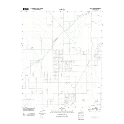
2012 Map of Willow Springs
USGS Topo · Published 2012About this map
Willow Springs sits at the base of the Tehachapi Mountains, serving as a historic waypoint where desert terrain meets critical infrastructure. The landscape is defined by the dual paths of the Los Angeles Aqueduct and the Second Los Angeles Aqueduct, which cut diagonally across the High Desert floor. This 2012 survey illustrates the transition from traditional desert ranching at the Wagon Wheel Ranch to modern recreational and aviation uses. The presence of the Willow Springs Raceway near the Willow Springs Butte and the private airstrip at Lloyd's Landing Airport highlights the area's development as a hub for speed and flight. Natural features like Bean Canyon and Bean Spring provide a geographical counterpoint to the rigid grid of named residential streets such as Champagne Ave and Golden Gate Ave extending into the arid flats.
Find a feature on this map
56 named features on this map. Tap any name to fly to it.
Don’t see what you’re looking for? This feature index may not catch every label — zoom into the map to look around manually.
Map Details
Editions of this 2012 Willow Springs Map
This is the sole edition of this map. No revisions or reprints were ever made.
Other maps of this area

1915 · Elizabeth Lake
USGS Topo · 1:125,000

1915 · Mojave
USGS Topo · 1:125,000

1917 · Elizabeth Lake
USGS Topo · 1:125,000

1943 · Rosamond
USGS Topo · 1:62,500

1943 · Tehachapi
USGS Topo · 1:62,500

1943 · Mojave
USGS Topo · 1:62,500

1943 · Willow Springs
USGS Topo · 1:62,500
1947 · Rosamond
USGS Topo · 1:24,000

1947 · Mojave
USGS Topo · 1:24,000

1947 · Soledad Mountain
USGS Topo · 1:24,000