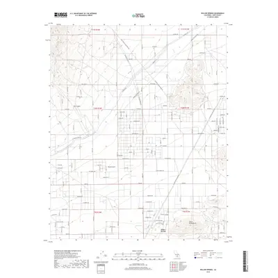
2018 Map of Willow Springs
USGS Topo · Published 2018About this map
Willow Springs sits at the base of the prominent Willow Springs Butte in this desert landscape of Kern County. This area reveals the essential water infrastructure of Southern California, prominently featuring the paths of the Los Angeles Aqueduct and the Second Los Angeles Aqueduct as they traverse the western edge of the Mojave Desert. The map records a complex grid of rural roads and desert tracks, such as Tehachapi Willow Springs Rd and General Petroleum Rd, which serve scattered residential developments and historic sites like Bean Spring. The transition from the steep elevations of Bean Canyon and Oak Cr in the north to the flat desert floor illustrates the unique topographic character of the Antelope Valley region. Local history is etched into the landscape through family-named thoroughfares like Billie Ave and Mc Connell Ave, reflecting the modern settlement pattern of this arid corridor.
Find a feature on this map
58 named features on this map. Tap any name to fly to it.
Don’t see what you’re looking for? This feature index may not catch every label — zoom into the map to look around manually.
Map Details
Editions of this 2018 Willow Springs Map
This is the sole edition of this map. No revisions or reprints were ever made.
Other maps of this area

1915 · Elizabeth Lake
USGS Topo · 1:125,000

1915 · Mojave
USGS Topo · 1:125,000

1917 · Elizabeth Lake
USGS Topo · 1:125,000

1943 · Rosamond
USGS Topo · 1:62,500

1943 · Tehachapi
USGS Topo · 1:62,500

1943 · Mojave
USGS Topo · 1:62,500

1943 · Willow Springs
USGS Topo · 1:62,500
1947 · Rosamond
USGS Topo · 1:24,000

1947 · Mojave
USGS Topo · 1:24,000

1947 · Soledad Mountain
USGS Topo · 1:24,000