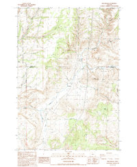
1987 Map of Willowdale
USGS Topo · Published 1988About this map
Willowdale serves as the central focal point for this high-desert landscape near the Wasco and Jefferson County line during the late 1980s. The area is defined by its dramatic drainage networks, with Trout Creek and its many tributaries, such as Pony Creek and Antelope Creek, cutting deep through the terrain. A notable pipeline and Route 97 provide the primary infrastructure through the region, reflecting the utility-driven development of the era. To the west, the Deschutes River Recreation Lands suggest the area's transition toward protected public use. Prominent landmarks like Friends Peak and Pony Butte tower over the surrounding canyons, while small-scale industrial sites, including a Gravel Pit and quarry, point to the local extraction economy that supported road building and regional maintenance during this period.
Find a feature on this map
23 named features on this map. Tap any name to fly to it.
Don’t see what you’re looking for? This feature index may not catch every label — zoom into the map to look around manually.
Map Details
Editions of this 1987 Willowdale Map
This is the sole edition of this map. No revisions or reprints were ever made.
Other maps of this area

1928 · Madras
USGS Topo · 1:125,000

1931 · Madras
USGS Topo · 1:125,000

1955 · Bend
USGS Topo · 1:250,000

1957 · Bend
USGS Topo · 1:250,000

1958 · Bend
USGS Topo · 1:250,000
1962 · Kaskela
USGS Topo · 1:24,000

1962 · Gateway
USGS Topo · 1:24,000
1963 · Madras East
USGS Topo · 1:24,000

1966 · Willowdale
USGS Topo · 1:62,500

1968 · Ashwood
USGS Topo · 1:24,000