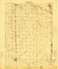
1906 Map of Willows
USGS Topo · Published 1914About this map
The agrarian development of the Sacramento Valley is captured here in the years following the turn of the century, centered on the growing rail hub of Willows. The landscape is dominated by large land grants and irrigation projects, most notably the Larkins Children Rancho and the sweeping course of the Central Irrigation Canal. Transportation defines the local economy, with the Southern Pacific Tehama and San Francisco Line moving goods through settlements like Germantown and Lyman, while the Northern El RR serves the northern reaches near Hamilton. Water sources such as Stony Creek and the various forks of Willow Creek provide the essential resources for the surrounding orchards and fields. Small landings and river-adjacent sites like Sidds Ldg and Jacinto indicate the continued importance of the Sacramento River corridor for local commerce and transport.
Find a feature on this map
25 named features on this map. Tap any name to fly to it.
Don’t see what you’re looking for? This feature index may not catch every label — zoom into the map to look around manually.
Map Details
Editions of this 1906 Willows Map
2 editions found

Other maps of this area

1888 · Marysville
USGS Topo · 1:125,000

1891 · Chico
USGS Topo · 1:125,000

1891 · Marysville
USGS Topo · 1:125,000

1893 · Chico
USGS Topo · 1:125,000

1894 · Marysville
USGS Topo · 1:125,000

1895 · Marysville
USGS Topo · 1:125,000

1895 · Chico
USGS Topo · 1:125,000

1904 · Vina
USGS Topo · 1:62,500

1904 · Walker Creek
USGS Topo · 1:31,680

1904 · Logan Creek
USGS Topo · 1:24,000