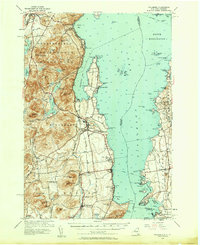
1956 Map of Willsboro
USGS Topo · Published 1958About this map
The Boquet River meanders toward Lake Champlain in this mid-century survey of the New York-Vermont borderlands. The landscape is defined by the sharp transition from the elevated peaks of Adirondack State Park, including Rattlesnake Mtn and Sugarloaf Mtn, to the fertile lowlands and bays of the shoreline. Settlement patterns follow the transportation corridors of the Delaware and Hudson railroad on the New York side and the Rutland line in Vermont. Cultural landmarks such as the Lady of Hope Shrine near Essex and the Whallon Bay Sch reflect the established rural communities of the 1950s. The map details a maritime geography of points and coves, from Willsboro Point to the small islands of The Four Brothers, illustrating the interconnectedness of lakefront villages like Charlotte and Willsboro.
Find a feature on this map
97 named features on this map. Tap any name to fly to it.
Don’t see what you’re looking for? This feature index may not catch every label — zoom into the map to look around manually.
Map Details
Editions of this 1956 Willsboro Map
4 editions found
Other maps of this area

1894 · Elizabethtown
USGS Topo · 1:62,500

1894 · Port Henry
USGS Topo · 1:62,500

1894 · Plattsburg
USGS Topo · 1:62,500

1895 · Willsboro
USGS Topo · 1:62,500

1895 · Elizabethtown
USGS Topo · 1:62,500

1895 · Ausable
USGS Topo · 1:62,500

1898 · Port Henry
USGS Topo · 1:62,500

1901 · Elizabethtown
USGS Topo · 1:62,500

1903 · Ausable
USGS Topo · 1:62,500

1903 · Middlebury
USGS Topo · 1:62,500