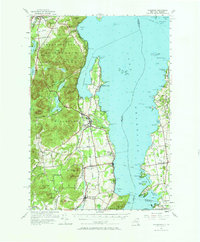
1956 Map of Willsboro
USGS Topo · Published 1969About this map
Lake Champlain dominates this 1950s perspective of the Adirondack coast, where the Bouquet River meets the deep waters of Willsboro Bay. The landscape transitions from the high peaks of the Adirondack State Park, including Bigelow Mtn and Rattlesnake Mtn, down to the fertile shoreline plains of Essex and Willsboro. This era shows a well-established transportation network, with the Delaware and Hudson railroad hugging the coast while the ferry connects Charlotte on the Vermont side to the New York shore. Local heritage is preserved in the numerous rural landmarks, from the Lady of Hope Shrine near the lake to the Whallon Bay Sch and remote upland burials like Reber Cem. The map reveals the early development of lakeside communities such as Craterclub and the seasonal character of Willsboro Point.
Find a feature on this map
121 named features on this map. Tap any name to fly to it.
Don’t see what you’re looking for? This feature index may not catch every label — zoom into the map to look around manually.
Map Details
Editions of this 1956 Willsboro Map
4 editions found
Other maps of this area

1894 · Elizabethtown
USGS Topo · 1:62,500

1894 · Port Henry
USGS Topo · 1:62,500

1894 · Plattsburg
USGS Topo · 1:62,500

1895 · Willsboro
USGS Topo · 1:62,500

1895 · Elizabethtown
USGS Topo · 1:62,500

1895 · Ausable
USGS Topo · 1:62,500

1898 · Port Henry
USGS Topo · 1:62,500

1901 · Elizabethtown
USGS Topo · 1:62,500

1903 · Ausable
USGS Topo · 1:62,500

1903 · Middlebury
USGS Topo · 1:62,500