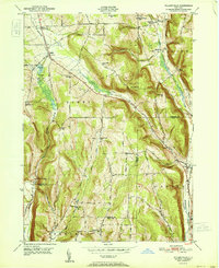
1951 Map of Willseyville
USGS Topo · Published 1951About this map
Danby and the surrounding rural uplands of the Southern Tier are defined by a network of narrow valleys and high ridges in the early 1950s. The landscape is deeply influenced by the paths of the Delaware Lackawanna and Western and Lehigh Valley railroads, which parallel the watercourses of Willseyville Creek and Danby Creek. These rail lines connected small agricultural hamlets like Willseyville and Caroline Depot to larger regional markets.
Find a feature on this map
46 named features on this map. Tap any name to fly to it.
Don’t see what you’re looking for? This feature index may not catch every label — zoom into the map to look around manually.
Map Details
Editions of this 1951 Willseyville Map
This is the sole edition of this map. No revisions or reprints were ever made.
Other maps of this area

1893 · Ithaca
USGS Topo · 1:62,500

1895 · Ithaca
USGS Topo · 1:62,500

1900 · Dryden
USGS Topo · 1:62,500

1902 · Waverly
USGS Topo · 1:62,500

1903 · Owego
USGS Topo · 1:62,500

1905 · Watkins Glen
USGS Topo · 1:125,000

1906 · Catatonk
USGS Topo · 1:125,000

1949 · Ithaca West
USGS Topo · 1:24,000

1949 · Ithaca East
USGS Topo · 1:24,000

1949 · Willseyville
USGS Topo · 1:24,000