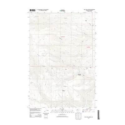
2014 Map of Willy Dick Canyon
USGS Topo · Published 2014About this map
Willy Dick Crossing marks a specific point of movement across the landscape of Yakima County, where the terrain transitions between complex ridge systems and canyon floors. This 2014 survey captures a network of Bureau of Indian Affairs roads, such as Bia 104 RD and Bia 187 RD, which provide access to high-elevation points like Deer Butte and the elongated Kah Mah Singh Ridge. The geography is defined by its water sources and livestock history, evidenced by Fairview Spring and the Wild Horse Corral located near Coon Canyon. The drainage patterns of Toppenish Cr and its tributaries, including Clock Cr and Camp Cr, illustrate the natural irrigation of the valley floor below Stamill Flat. This map offers a clear look at the intersection of traditional land use and modern infrastructure within the tribal land system.
Find a feature on this map
28 named features on this map. Tap any name to fly to it.
Don’t see what you’re looking for? This feature index may not catch every label — zoom into the map to look around manually.
Map Details
Editions of this 2014 Willy Dick Canyon Map
This is the sole edition of this map. No revisions or reprints were ever made.
Other maps of this area

1904 · Mount Adams
USGS Topo · 1:125,000

1907 · Mount Adams
USGS Topo · 1:125,000

1937 · White Swan
USGS Topo · 1:125,000

1950 · Yakima
USGS Topo · 1:250,000

1957 · Yesmowit Canyon
USGS Topo · 1:24,000
1957 · Willy Dick Canyon
USGS Topo · 1:24,000

1958 · Fort Simcoe
USGS Topo · 1:24,000

1958 · Fort Simcoe
USGS Topo · 1:62,500
1958 · Medicine Valley
USGS Topo · 1:24,000

1958 · Yakima
USGS Topo · 1:250,000