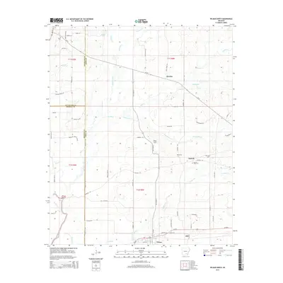
2014 Map of Wilmar North
USGS Topo · Published 2014About this map
The timberlands and creek bottoms of southern Arkansas come into focus in this modern survey of the borderlands between Drew, Bradley, and Cleveland Counties. Wilmar sits at the southern edge of the sheet, served by a network of local roads such as Wilmar Loop and Gates Ave. The surrounding landscape is defined by the winding paths of Langford Cr, Hudgens Creek, and Hungry Run Cr. Evidence of the area's rural heritage is visible in the scattered settlements of Barkada, Brandon, and Allis. Genealogy enthusiasts will find several historically significant burial sites, including Union Cem, Bethel Cem, and Torian Cem. The Wilmar Lookout Tower stands as a notable landmark overlooking the intersection of forest and farmland, while Bradley Ford indicates a traditional crossing point along the western watercourse.
Find a feature on this map
74 named features on this map. Tap any name to fly to it.
Don’t see what you’re looking for? This feature index may not catch every label — zoom into the map to look around manually.
Map Details
Editions of this 2014 Wilmar North Map
This is the sole edition of this map. No revisions or reprints were ever made.
Other maps of this area

1935 · Feenyville
USGS Topo · 1:62,500

1953 · Greenwood
USGS Topo · 1:250,000

1953 · El Dorado
USGS Topo · 1:250,000

1956 · Greenwood
USGS Topo · 1:250,000

1957 · El Dorado
USGS Topo · 1:250,000

1958 · El Dorado
USGS Topo · 1:250,000

1960 · El Dorado
USGS Topo · 1:250,000

1966 · Monticello North
USGS Topo · 1:24,000
1966 · Monticello South
USGS Topo · 1:24,000

1970 · Herbine
USGS Topo · 1:24,000